Friday, September 6, 2013

Chacaltaya to Huayna Potosi

Yesterday was an even bigger day: Our first ascend to 5,400m (17,700 feet). The cool part is that Chacaltaya  used to be a ski resort, until about the mid 2000s when the glacier receded so much that skiing is no longer possible there, so that there is a road that leads to 5,200m. This is a happy thing, as it means we only ascended 200 more metres for awesome summit views.
The former ski lodge now serves to receive hikers. It is run by the Bolivian Club Andino.
This must havebeen quite a place in its heyday.

After our brush with altitude queaziness yesterday, we were happy to feel good and ready for this day. We ascended truly to 5,400m, despite what the altimetre says.
Height of the first peak on the way to the second, higher peak.

Looking good with Huayna Potosi in the background.

Just wow. Really. The Cordillera Real is majestic, and we got to see all 200 km of it from here.

We spend about four hours around 5,300m hiking and admiring. The hiking was challenging as there are no well-trodden paths in this area. In fact, our guide, Cesar Renjel, who guided us here and at Condoriri, had not done this hike since last year. Most who visit Chacaltaya just hike up the short distance to the second peak and go back to the lodge and descend.

The very top of Chacaltaya at 5,400m. Again, starring Jan, Inga and Huayna Potosi. Amazed we actually climbed that 6,088m mountain three years ago.

The morain side made for a steep and fluid descend. Ceasar led the way and we employed our skiing skills, keeping our bodies facing the fall line.

Lunch at 5,100m. I am feeling this excursion a bit, with little appetite I choke down half a
sandwich,two cups of mate de coca, peanuts and a coconut chocolate bar. Not bad for staying energized
for the final descend to 4,800m where the car awaited us.
Amazingly, we both fared overall much better than yesterday at the lower altitude of Condoriri. We both just relaxed a bit when we got back to our casita, but were up and about to catch an unscheduled coffee date with Isabel, our lovely hostess.

It helps to be sleepnig low at about 3,500m, so we recover fully.

This morning we met with Eduardo, our mountain guide for the next 16 days. We will leave tomorrow at 8 am, for an 11 day stint in the Chearoco and Chachacomani areas. Depending on snow and ice conditions, we will have lots of time to practice glacier travel skills as well as make ascents of mountain peaks around 5,400m or so. If all goes well, we are also looknig at those two mountains over 6,000. Vamos a ver.

Tuni to Chiar Qota/Condoriri

Wednesday was a big day: our first foray well above 4,000m hiking from Tuni to Chiar Qota in the Condoriri area. This area features mountains up to about 5,800m. And with the snow of late, many peaks at ¨lower elevations¨like Pico Austria, which we climbed 3 years ago, with its 5,300m had some snow.
A perfect mirror: laguna and sky. Great shot by Jan :)

We drove to about 4,300m by car, basically up the valley on some unmaintaned dirt road, then hiked over about 2.5 hours to roughly 4,700m (about 15,400 feet). While the hiking is easy using well trodden paths, the altitude does make for slow but steady progress. And the vistas are awesomely beautiful.

In the background is La Cabeza de Condoriri (head) and to the north and south are its wings. Pico Austria, which we climbed three years ago, is the nearest snowy peak.

After a fine lunch at the refugio at the laguna Chiar Qota, we took a walk around the laguna and admired the views along the way.

On the way back down I started to feel a bit of that queaziness that comes from active acclimatization: the beginning of a slight headache, slight oddity in the stomach. But I made it back to the car fine. Jan was just motoring along. On the car ride back, I felt quite bad but recovered by dinner time. Jan on the other hand developed that queazines and didn´t have much appetite at all. The good news: by morning we had both fully recovered our wits and got ready for Chacaltaya.

Happy, but starting to feel altitude effects on the way down. 
Totally gorgeous laguna Tuni with the Cordillera Real as backdrop. This is at about  4,350m at the end of this day´s  excursion.

Thursday, September 5, 2013

On horseback to the Muela del Diablo -- que lindo!

Combining the grandeur of nature south of La Paz with horseback riding surely is a winning combination. On yet another blue sky day (!) we headed off with our guide to experience a three hour ride to the Muela del Diablo (the Devil´s Tooth). As well as being an impresse rock formation, the Muela del Diablo has a few myths attached to it. One is the story of a black slave who fled his keepers and found refuge in the rock. Folklore has it that he stole food and clothing from the locals and, once found out, met with his death in their hands. Another story has it that the Muela del Diablo was (is?) the spot locals went to in order to practice their sacrificial offerings (I like the first version of the story better, I must say, notwithstanding the death of the  poor man). In any event, as an adventurer on horseback, the Muela del Diablo and the "Lost Valley" we rode through made for some magnificent moments in nature.

At 3,850m with the infamous Muela del Diablo behind them, Jan and her horse, Muñeca, stand tall  (as they can),
beside Inga and her horse, Mulata.


The Muela del Diablo was only one of the several "western movie" rock formations.

Although inviting, the rock is not suitable for climbing as it is  more like  dense mud than rock. These  artistic shapes were formed over time by the downpours of the rainy seasons.


Inga was pleased with her ride. Ride´em, cowgirl.

The stable we went to had 12 horses, seven ponies, a couple of  alpacas, one lamb (who thought it was an alpaca),  as well as some pigs and chickens. Our horseback riding ended up being an afternoon at the farm.


Get it while the getting is good.

Tuesday, September 3, 2013

Tiwanaku civilization

Yesterday, we went on a day trip to a major archeological site near Lago Titicaca, called Tiwanaku. It is amazing to think that a civilization that developed over close to 2,700 years and achieved obviously significant scientific knowledge would simply disappear into oblivion. And yet, there is so little known about this civilization and its apparent capabilities, it is almost shocking. I mean, the Inka empire lasted barely one century, and yet we seem to be fascinated by its achievements. Like Machu Picchu, Tiwanaku had to be discovered again to gain some importance as something more than a ¨quarry¨ for local construction and for looting of all its metal ornaments. Indeed, Isabel, our La Paz hostess told us that a museum in Berlin has the largest collection of gold from the Tiwanaku civilization.

For Tiwanaku we do not even know the name it was known by its original inhabitants. And, yet, the empire expanded to perhaps 2 million square km at its height. That´s one fifth of th size of Canada, which is huge.

Excavations are ongoing now, but proceeding slowly. The whole site was a jumble of stones, many impressive ones, but no one knows how they fit together. Reconstruction has been problematic as efforts are made to recreate the temples, but in some cases that has meant using adobe blocks to fill in blanks and in others cement has been used to aid that reconstruction.

This site is 72 km from La Paz and 20 km from Lago Titicaca in a valley that parallels the Cordillera Real. It sits at about 3,850 metres above sea level.
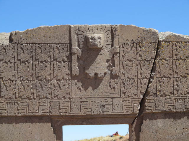
Detail of the Puerta del Sol. It served as a calendar. Like most ruins it is not in its original place.

A monolith that is well conserved, even though the Spanish tried to cut off its head. The stone was too hard. The images throughout the monolith are symbols important to this culture and some also serve a bit of time keeping.

The rebuilt Kalasasaya temple with another Puerta del Sol and a monolith that aligns perfectly on June 21 for solstice. Apparently thousands converge here to celebrate this event.

Semi-subterranean temple has many carved heads in the wall. I took pictures of the orignal ones but there are also seven copies that have been embedded in another wall to show what they might have looked like before erosion and looting.

How does an ancient civilization know to carve such perfect H? I´m just here for scale :)

The mathematical know-how and crafty skills are obvious in the detail of these carved rocks. No-one knows how this puzzle fits together now. 

Pumakuna featues huge stones, some weighing several tons. They carry obvious markings of areas where precious metals once adorned them. 

A small door with Jan offering scale this time :)

And yes, it is windy on the Altiplano! 

El día del peaton

Imagine this: Toronto or Montreal or Vancouver dedicating one day a year to a car-free day. Sounds quite unlikely, doesn't it? Well, that is exactly what La Paz does every first Sunday of September. This city of 1 million people, the world's highest de facto capital, celebrates El día de peaton (the day of pedestrians) to bring awareness to both the environment and health. It was mind blowing to experience La Paz without cars. This city bustles with cars and taxis and buses like no other city I have seen. As well, the carbon emissions are not controlled like in Canada, for instance. What you are left with is a lot of heavy spewing of exhaust. So for this city to turn around and be car-free is obviously a night and day experience.

We celebrated El día de peaton with the thousands of others who took part in the many activities set up across the city. On El Prado, one of the city´s main streets, Bolivians enjoyed more than three kilometres of fun such as skipping, art making, live street music, karaoke, not to mention getting around on various forms of transportation like stilts and inline skates and skateboards and bikes. This is not normally a city of biking so it was an unusual site. I must say that I held my breath a few times as I watched kids blasting downhill with great abandon. Good times.


These fine artists from El Alto, the city on the altiplano (the Andean plateau that sits at 4,100m) added to the festivities with their bright colours and enthusiastic music.

Ready and waiting for the budding artists.


Literally taking art to the street.


Giggling teenage boys testing out their double-dutch prowess. Hysterical.

A group of dancers put on an impromtu performance to the delight of all.

"Saxoman", as he called himself, put on a very fine, spirited performance, playing everything from traditional Bolivian music to jazz to Santana. Music truly is a universal language.

Can I be a "Saxoman" one day, too?

Sunday, September 1, 2013

La Paz - acclimatization going well

We are in La Paz now. Just catching up on Sucre and trekking near Sucre posts :)

Our acclimatization plan is working very well: no headaches at all so far and no issues with nausea, food or anything either. This is splendid.

We have booked 4 day-trips for this week. First a visit to Tiwanaku, an ancient civilization perhaps more advanced than most others in its heyday, then a half-day horseback riding excurison, both of these will see us around 3,800 to 4,000m. The third and fourth day will see us getting high. First to about 4,700 on a day hike from Tuni, about 2 hours from La Paz, to Chiara Qota, a laguna we slept at 3 years ago. Then a trip up to Chacaltaya (formerly the highest commercial ski resort in the world at 5,300m before the glacier melted due to climate change) and a hike over to the base camp at Huayna Potosi.

We sleep at about 3,500 m in La Paz, but walk up to 3,700 or 3,800 m. (around 12,000 feet). While that is normal here, it is amazing when you consider how few places in Canada exist at that altitude. There are just a handful outside the St Elias Range in the Yukon. Basically, while we would include being at such altitude in our mountain resume, being in La Paz makes it seem like nothing to write home about.

We are feeling great being here. Like 3 years ago we are staying at Casa Hermanos Manchego, with the lovely Isabel our host and her staff ever caring for our well being. We have already been to our favourite restaurant down the street and enjoyed tasty Thai at Maphroa On. It´s lovely to reconnect with people and places we know a little already.
(Post by Inga)

The 12 stations of the cross in Sucre

We are not actually into such things normally, but we found ourselves taking the long way to the Mirador in Sucre ;) We ascended about 300m to3,100m and then found ourselves in a place of worship and asking favours that is well used by the local people. Quite a few were up here, making offerings and such.

Jesus statue with altar inside on top of hill near downtown Sucre.

The 12th station of the cross. Each one had a monument like this. 

Then there was the actual mirador, very close to our B&B as it turns out, and while located much lower than Jesus, it also had lovely views over the city. Also just a few steps away is an amazing Indigenous art museum focussed on weaving. It also haas some historic artefacts, musical instruments and really well done explanations and videos. This is well worth the visit as it offers three different indigenous peoples traditions in one place. In recent years, there have been efforts made to recover thr lost knowledge of complex weavings and the results are stunning artistic - and practical - work
.
Inga enjoying the views from El Mirador, and about to have a well-earned lunch, too.

If you ever make it to Sucre: go here!

We also made it to the Case de la Libertad at Plaza 25 de mayo. It has a few rooms with artefacts of importance to Bolivia´s history, paintings of important generals and such.

Jan posing in la Casa de la Libertad in Sucre. She is standing beside the actual Declaration of Independence on display here. Simon Bolivar is in the centre on the wall with other major liberation figures beside him. Also Jan paid to be an official photographer, hence that tag she´s got on. I thought it amazing they´d allow photography inside these places and with these unique artefacts.

The stain glass above the senate room is gorgeous.

And finally one of the many churches in town.


Warm Jalq'a designed accommodations

The lovely pink connecting section of the habitacion featured coloured  glass to add light and tecture.
On our trek with Condor Trekkers, we slept both nights in lodging that was designed according to Jalq'a traditions. The Jalq'a people are indigenous people of Bolivia who still live according to their cultural traditions. The tourist lodging was constructed by the villagers and is run by the community, with all proceeds going to the community.

At the end of our second day of trekking, we arrived at our home for the night.

Each of  the cabañas had three sections: the entrance and kitchen (from the right); a connecting hall where the bathroom was, a common area, and a sleeping area with two bedrooms.

Soft coloured light from inside our warm abode.
Our knowledgeable and kind guide, Johnny, cooked up delicious vegetarian meals in the kitchen. How did he know that a bowl of warm oatmeal for breakfast was one of my favourites : )

Simple. Beautiful. Functional.

The craftsmanship -- not to speak of the work collecting the stones -- was truly inspiring. Although we did not
have to light a fire to stay warm (layers of clothing was all we needed), just the presence of this masterpiece
in the common area warmed us.

The dinosaur theme was joyfully caried through the appliqués. At night, I dreamed of times long passed.

This view, looking up from the area outside our casa, shows the adobe used to create walls, houses and fences. The sun was resplendent every day.

Dinosaur tracks and awesome landscape (Part 3)

Donkeys are part of the landscape. They, like all animals, roam freely.

Jan sitting at the edge of Maragua Crater having a well earned sip of water after ascending from 3,100 to 3,300 in just a few minutes first thing in the morning. OK, so I found that harder than she did :)

Dinosaur tracks. These are for real.

But Tyrannosaurus Rex made for huge tracks. The story is the tracks fossilized due to a vulcano eruption or some such.

Me with much smaller dino tracks. The people think that when other parts of the landscape are revealed with big rains, many more tracks will be found.
Lunch break at a beautiful spot overlooking the valley toward Maragua and sporting this sculpted hangout for Jan.

Potolo, our destination for night 2. While at 3,100m it has more water than other places along this track and farming was active already as a result.
Day two of the Condor Treking Excursion brought some impressive moments with Dinosaurs. The landscape moved from the copper reds to the silver greys and greens and much in between. These mountains are rich in minerals, but they apparently are not dense enough to warrant mining. There  are other areas nearby, for instance, Potosi and its silver mines. Most of this trek is above treeline, but it is more a matter of how arid various areas are.

The days start early out here - yes, breakfast at 6:30 am - and the rewards are amazing. We have about 12 hours of day light so all activity outdoors takes place in that window. Johnny, our guide, while a bit reserved, was fun to spend 3 days with, converse about life, natural features, rocks, tracks and his plans for a 1 year work exchange to Germany. He is flying to Hamburg in mid-September. (I promised him he would be received well, enjoy German hospitality and make real friends.)