Sunday, May 28, 2017

Alpine Club of Canada Gazette articles

The ACC's AGM including a film about the Yukon Alpine Centennial Expedition was in Whitehorse yesterday. The film was fun. The speaker that brought a crucial dimension to the evening was Parks Canada's field superintendent for southern Yukon, Diane, who described the cooperative management practices in the Yukon and NWT with indigenous people and their governments. I knew Kluane was co-managed but had not realized how far that had evolved. From the Canadian government banning First Nations whose traditional lands included Kluane National Park and Reserve from Kluane in the 1940s to cooperative management in the 1990s when First Nations started to conclude their land claim and self-governance agreements, there has been important progress.

I enjoyed meeting board members and section representatives. With a couple I was chatting about writing articles for the ACC, which made put this post together with links to all of them.

My fourth article on the week-long Spectrum Range/Mt Edziza traverse last August appeared in the Spring 2017 issue of the trice yearly ACC Gazette,

My Kluane Icefield Discovery camp story in its Winter 2015 issue. That one made the cover, thanks to my fellow campers great photography (yeah, Charles Stuart!) This one was more of a team effort, with ACCers contributing photos and offering edit suggestions on a draft text.
The Summer 2014 issue details a trip to Bolivia's remote parts of the Cordillera Real and doing a first female ascent to Pico Aguila at about 5,500m.

The Winter 2012 issue features one week of a 3 months Andean adventure focused on the stunning Cochamo valley in the Chilean Lake District in Northern Patagonia.

I make a point in recent articles of referencing the original stewards of the land on which I spend time. To me it is important to acknowledge and situate myself in the proper context as a matter of respect, appreciation and reciprocity. In speaking with an ACC board member I think it could be a significant act of conciliation for the ACC, a club intrinsically linked to the land and stewardship of our natural world, to begin to do so as a matter of policy in its publications both online and in print. Something worth thinking about.

Tuesday, September 27, 2016

Colour and Light: Traversing the Tahltan Highlands

“Trip partner(s) wanted: remote ~12 day traverse in Mount Edziza Park in northern BC, across the Spectrum Range and along Mt. Edziza. It will be a challenging trip (no trail), but non-technical. Float plane charter into Little Ball Lake and flight out of Buckley Lake.”

I had never heard of this area; the promised duration and remoteness were immediately appealing. This Facebook post on the ACC Yukon page was from a Jordan Anderson. We made contact and met in Victoria in June. During a 30 km overnight hike on the Juan de Fuca trail we checked our attitudes, hiking styles, ultra-light and emergency gear and whether we’d enjoy each other’s company.

Amazing colours of the Spectrum Range
(Photo: Jordan Anderson)
With a successful hike behind us, we finalized plans. Jordan proved to be a stellar route planner and navigator, targeting nine days of hiking. I organized the food. There were meticulous gear lists, nutrition tables, some emails and phone calls.

I met Jordan in Smithers, BC on August 1. Gear quickly overflowed the motel room. By evening’s end we had two backpacks ready to go. The next day we drove six and a half hours north to Tatogga Lake Resort to meet our Alpine Lakes Air charter.

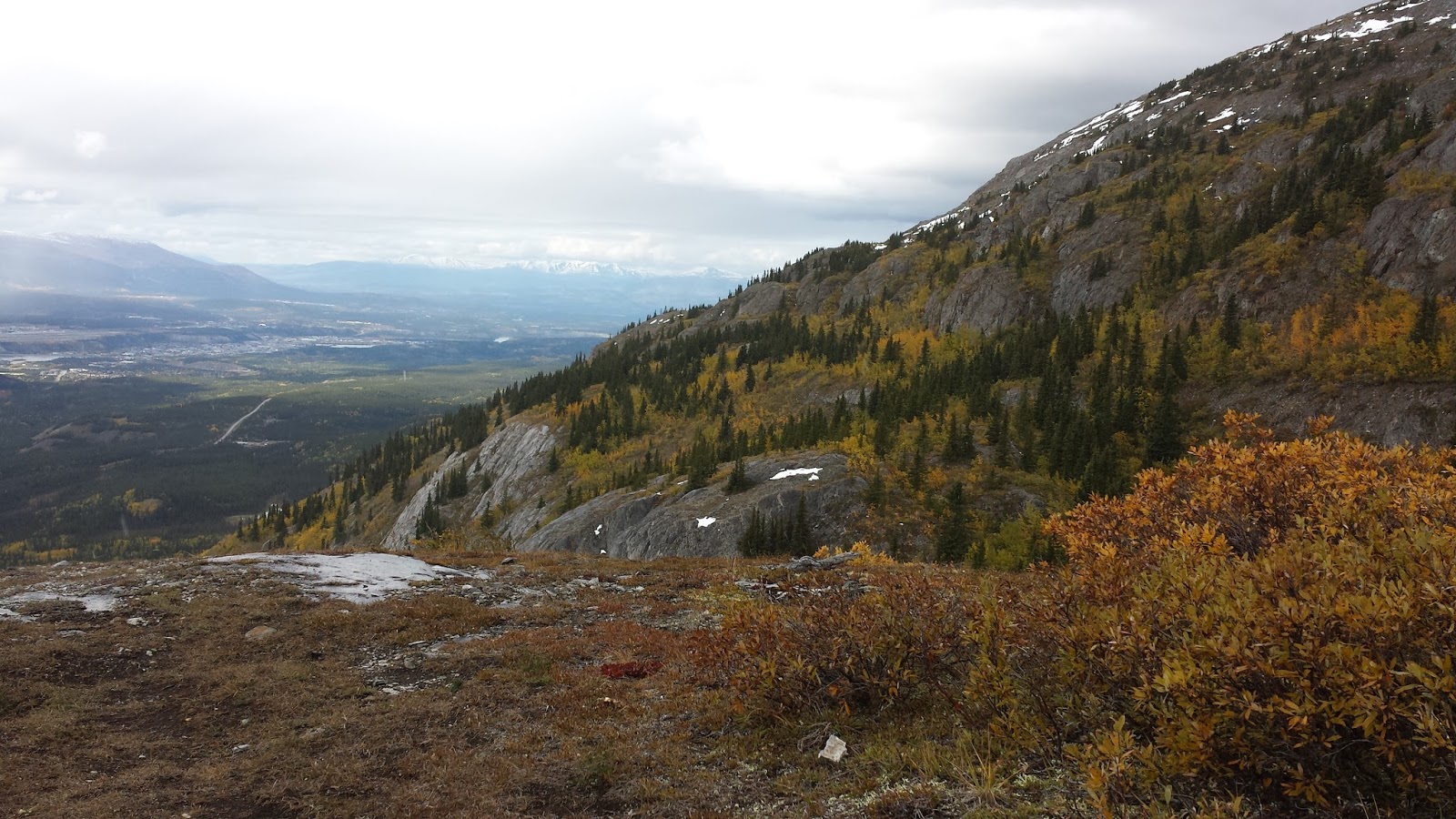
As the float plane left us alone, we felt the elation of having arrived in a vast wilderness without an escape route; a world of self-reliance and trust in each other. The saturated alpine landscape immediately embraced us. Its bright blue skies welcomed us as the evening sun began to draw long shadows. Mountains in every shade of gold were capped by pristine snow fields. Green patches interrupted the creek bed gravel.

Day 2 - Camping spot (Photo; Inga)
We shouldered our packs, rounded the lake and started up valley.

Northern summer days afford the luxury of late starts and long days. To me, these latitudes offer the best kind of hiking; and Jordan came to relax about not striking out by 8 am every day.

Day two brought us across our first pass and an abundance of ever changing colours creating countless impressions of the Spectrum Range. I slowly found my uphill legs; and then eased the knee-busting downhills with a well-practiced handling of hiking poles. 

500 metres uphill on loose scree. (Photo J Anderson)
We took note of obsidian littering the landscape. Obsidian reminds us that this provincial park is part of the Tahltan Highlands. The Tahltan people - the original people of this spectacular wilderness - have not given up Aboriginal Title to their territory. Edziza obsidian, the dark volcanic glass used to make sharp tools in ancient times, was used and traded by the Tahltan and has been found on the west coast and in territories toward the east. The human story here reaches back to time immemorial; as visitors we respect the land by leaving no trace and taking nothing but photos.

At the end of our first full day of hiking, we contemplated the second significant pass of this traverse and decided to tackle the 500-metre ascent the next morning. While I set up camp on a knoll, Jordan descended a few hundred meters to fetch water. We settled into our new camp routine and enjoyed stupendous evening views across this huge valley.   

Day 4 - we climbed most of this scree slope side-by-side
as boulders kept falling into the valley. (Photo: J Anderson)
Day three started out fine: Our plan was to take the direct route up and veer left at about 2,100 metres toward the low end of the ridge to avoid the glacier on the North-side. Alternating between the direct line and zig-zags, we carefully navigated the continuous movement of boulders. This scree slope exhaled and settled with each step.

As we progressed upwards we reached the edge of the clouds and visibility was reduced to as little as 20 or 30 metres. I trailed Jordan. As the weather moved in, we lost sight of each other and proceeded to independently execute the plan. When I reached the ridge, now fully engulfed in a cold, lashing rain and sleet, I found Jordan greatly relieved.

In full rain gear and after a quick snack, we crossed to the other side and realized that we needed to go further left to reach the rocks and mud rather than get caught in a potentially uncontrollable descent of the glacier itself. As we lost elevation we left the clouds for a time, took short breaks, replenished our water bottles and encountered two very curious mountain goats; their climbing skills clearly outdid ours.

Drenched to the skin we spent the next several hours moving across another dazzling valley, up another high pass onto a large plateau. With the change in elevation the stormy weather returned and we set up camp in the rain. Shivering and unable to light the stove we decided to forgo a hot dinner in favour of stripping off our wet clothes and crawling into our dry sleeping bags. The weather didn’t relent. We faced the next day knowing we didn’t have much margin left if the weather didn’t improve: after breakfast we set out in soaked boots and soggy clothes motivated to move and stay warm.

Highly dynamic jump with a 55+ pound pack. (Photo: Inga)
Finally that afternoon the weather broke. We kept moving through this wilderness, grateful for the warmth of the sun, taking each scree slope and pass in good humour to balance the dangers, astounded by Mount Edziza - the “Ice Mountain”, admiring near perfect volcanic cinder cones, glad for low running creeks and thoughtful about crossing the others.


We completed the traverse on day 7 with a final push of more than 30 km to Buckley Lake. A rare 8 am start ensured that we crossed every creek by rock hoping and arrived 11.5 hours later at the dock on Buckley Lake. To our amazement we found ourselves walking into Creyke’s hunting camp that Leonard Creyke and members of his family were visiting. He had spent years guiding in the area; this was his first visit in some time. It was a remarkable conclusion to this journey: sharing an evening of conversation, stories of his Tahltan family and the sacred land we had walked, and a dinner of freshly caught lake trout.
Mount Edziza.

(As submitted to the Alpine Club of Canada, Gazette)

Saturday, July 9, 2016

Iqaluit's Alianait Arts Festival magic

While attending Alianait I was generously hosted by Heather Daley, the festival's director. It was a pleasure to experience the magic of this festival that focuses on bringing circumpolar, Inuit and other indigenous artists together with select Southern Canadian musicians. The festival includes professionally produced shows at the Nakasuk school auditorium's stage, musical jams, theatre, and workshops. Many musical genres are represented from fiddles and accordion, to throat singing, blues, rock and more.

It runs over Canada Day so that its big top becomes a focal point for this community celebration.

I was invited to post-show artist get-togethers and experienced joyous musical collaborations. Artists coming from Nunavut, Greenland, Northwest Territories, Mongolia, Iran, southern Canada mingled together at parties and invariably music ensued, with a great deal of curiosity and exchange about each others styles and vibes.

This video of Simon Lynge jamming with the assembled crew shows merely one of many highlights.


REND from Edmonton played two great shows, including
Canada Day show in the big top. Representing alternative rock.

Members of Sedaa share their music mixing Inuit drums and
their style of throat signing to great delight of party-goers.
World fusion jam made a truly magic soundscape.
Sedaa, Barrule (Isle of Man), Sylvia Cloutier (Nunavut),
Tiffany Ayalik (Yellowknife)

Mongolian musician explains their style of throat signing
to Inuit and southern Canadian musicians.
Blues jam on stage: The Tradeoffs (Iqaluit),
Quantum Tangle (Grey Gritt and Tiffany Ayalik, Yellowknife),
The Harpoonist and the Axe Murderer (Vancouver)

Iqaluit, Nunavut in summer

I spent 6 days in Iqaluit, Nunavut during the Alianait Arts Festival, from June 29 to July 4. Summer on the tundra and on Frobisher Bay is a remarkable experience.

With Nunavut's much shorter summer than the one I've been enjoying in the Yukon - at similar latitudes - there is a sense of urgency to take in the sun, be outside, participate. Here are a few impressions of the landscapes and town. (Simply click on an image to see it in larger slide show mode.)


The big top flew the Pride flag for the first time. It was a much
appreciated gesture after the Orlando massacre in Florida.
A stunning sunrise around 2:00 am. The nights don't get
dark this time of year, as the sun merely dips below the
horizon for a short while.
Panorama over the Road to Nowhere toward Frobisher Bay

The draw of the Big Top after the Canada Day Parade
Dynamic skies over the tundra beach at Frobisher Bay.
Frobisher Bay panorama showing the ice breaking up. The first icebreaker of the season was expected within a few days,
clearing the way for the all important Sealift later in July.
Beautiful light around 2 in the morning.


Saturday, July 2, 2016

Juan de Fuca trail, Vancouver Island

Taking advantage of a work trip to Victoria, BC, I met up with a fellow trekker, Jordan, to do an overnight hike on the Juan de Fuca trail on the last weekend in June. The challenges were a Saturday afternoon start for the drive out, only one car to manage a point-to-point hike and catching a red eye flight to Ottawa the next evening.

https://share.delorme.com/IngaPetri 
Success would require steady movement and a bit of luck: from dropping the car at our end point at Sombrio Beach and hitchhiking back to the trail head at China Beach, to making it to Bear Beach for our overnight, and an early start for the most challenging part of the hike. In total we would hike about 29 km with considerable cumulative elevation gain as the trail meanders along the coast from sea level up to 231 m and is hardly ever actually flat.

We managed it all with ease. The sweltering heat was kept at bay by the trail running through coastal forest and therefore endless shade. The timing issues with night fall and an early rise were handled deftly - such is the nature of necessity. We fueled well and made sure we stayed hydrated. We also got to take a look at our respective gear - from my inReach and ultra light 3 person tent, to Jordan's awesome cooking set up and creek crossing foot wear. Between the two of us, we seem to be in the right gear kind of shape for a long, unsupported remote traverse.

This trip was an exploratory excursion to see whether my new hiking pal and I would enjoy a 10-day remote back country trek in Northern BC this August. It appears we are the kind of compatible you'd want to be for an excursion like that. Now, there is just one final logistical item to iron out and we'll make a final decision about whether this trek is a go next month sometime next week.

Meanwhile where are a few impressions from Juan de Fuca. (Click on images to see them larger in slide show mode)
Morning fog from our camp side hideaway on Bear Beach.

Morning fog burns off.

Bear Beach views

For some a sign is reassurance. Then again, there is only one trail.

View from the trail.

Lots of creeks giving opportunity to experiment with camera settings.

Sombrio Beach was our end point this time. Heading up to the car
 and back to Victoria with enough time for a shower
before going to the airport ;)

Saturday, February 27, 2016

Seeking: mountaineering partner for Aconcagua 2018

Seeking: mountaineering partner/s interested in the South American Andes between about 15 and 40
To  Plaza de Mulas, the climbing base camp.
degrees South (i.e. Altitudes of more than 6,000m/20,000 feet, relatively little snow or glaciers). 


My objective: to climb Aconcagua in Argentina in 2018 (summit just short of 7,000 m).

I'm looking for people to plan, train (think epic Yukon treks, long Eastern US/Canada through hikes, trips at altitude) and climb this impressive mountain. Regular climbing season on Aconcagua runs from mid-November to mid-March. The trip takes about 3 weeks, but I'll need more time to acclimatize and likely would do so in Bolivia's high mountains. Intrigued? Interested? 
The Polish route sen from Plaza Francia
(not considering that one so much)


Check out:


You'll see, Jan, my long-time partner in life and the mountains in many of these posts. Unfortunately, that partnership ended last year, so I am looking for a new 'travel in high places' partner.


Message me here and let's talk!

Aconcagua Normal route seen from Plaza de Mulas
at about 4,450 m. Summit at 6,962 m (22,840 feet)


Sunday, November 15, 2015

Winter hiking near Whitehorse

I've been in Whitehorse since Friday. Happily I wrangled some hikes around town with some of my new Yukon friends and their Yukon dogs. There is snow everywhere, but in the higher elevations it is the best kind of winter. Super dry cold - can one ever moisturize enough up here?! - gorgeous fluffy snow on all the trees. A certain monochromatic whiteness and ever changing skies.

Dressing for this weather is much simpler than the damp cold in Ottawa and similar locales. Basically, with the right mix of performance clothing the cold stays outside; it just doesn't get into your bones. Also, there was no wind today. Wind makes such a ridge walk a whole different sort of experience. When we started the hike today it was probably around -18C or so. It felt fine and there was some de-layering needed on the uphill portion.

Our high point today was 1,507 m. We climbed 400 m from Fish Lake Road to the top of the ridge, according to my inReach. As Whitehorse is around 700 m, it doesn't conjure quite this wintry feeling, yet.

The scenery is crazy gorgeous. I mean it is stunning in the summer here but mind-blowing now. Check out today's Fish Lake hike up on to the ridge.

The view across Fish Lake from the ridge.

Walking along the ridge.

This Yukon dog really didn't appreciate standing still on
the snow.  Do check out the backdrop!
The human hiking pals, some I met a few months ago, some today.
That is how it rolls. 

Short breaks make for happy hikers.

Snow covered trees in the sunlight.

The Ridge. We are just above the treeline here.
Fun hike.

Monday, November 9, 2015

ACC Gazette published my story on Icefield Discovery

Full story:
http://acc.uberflip.com/i/594756-winter2015gazette
The Alpine Club of Canada's Gazette, the ACC trice yearly members' magazine, has just published my Icefield Discovery camp story in its Winter 2015 issue. And it made the cover, thanks to some fellow campers great photography! This one was more of a team effort, with ACCers contributing photos and offering edit suggestions on a draft text.

Read the full story and see more great pics here.

This is my third ACC Gazette article in the last few years. The other two are:
The Summer issue in 2014 detailing a trip to Bolivia's remote parts of the Cordillera Real and doing a first female ascent to Pico Aguila at about 5,500m.

The Winter issue in 2012 detailing one week of a 3 months Andean adventure focused on the stunning Cochamo valley in the Chilean Lake District in Northern Patagonia.

It's fun to spend this kind of time in some amazing mountains on this Earth of ours.

Wednesday, September 16, 2015

My first Yukon paddle: Chadburn Lake

My last evening in Whitehorse this September, a friend took me out for my very first paddle in the Yukon. As it was a post-work excursion we kept it simple: flat water kayaking on Chadburn Lake. This beautiful spot is within city limits in Whitehorse. I don't know if it ever gets busy there, but there were just three of us on his lake that evening. We paddled until dark and enjoyed visiting with a beaver, ducks and perhaps even a loon, and each other.

It was a perfect evening.

My ride with my ride - thanks to Up North Adventures for the kayak.
Reflections. Evening Light on Grey Mountain. 


Solitude and silence.

That's me on Chadburn Lake. Thanks for this cool photo! (by Kalin Pallett)

Light and dark as the sun begins to set.

Tuesday, September 8, 2015

Hiking around Whitehorse: Grey Mountain Traverse


Today's GPS tracking points.
https://share.delorme.com/IngaPetri
Today we spent another day hiking, bushwhacking and ridge walking. The objective: A north - south traverse of Grey Mountain ridge. I think traverses are always a really cool thing.

View of Whitehorse from one of the most northern ridges. 
We set up a vehicle shuttle, so we could avoid hiking along the dirt road at the end of this 7.5 hour hike. That way our energy was focused on the high-reward aspects of this impressive traverse.

Starting on the north side we had to climb about 200 m more in terms of elevation. That was well worth the effort: we ascended the ridge one intermediate summit after another, offering exquisite views and culminating in the highest summit on the south end.

One challenge was finding the up-track once the trail faded amongst the brush and many fallen trees. We were happy that Jeanne had loaded up a GPS track, so we could avoid backtracking as we meandered uphill. The bushwhacking and trail-finding was made more challenging by early season snow.

The view of the south summit of  Grey Mountain.
Once we gained the first high point, the view overlooking Whitehorse was immediately impressive. And it only got more so, as we headed further up on our south-ward trajectory and gained views from Lake Laberge to Marsh Lake and the mountains beyond.

We also got a fine view of the still snow-clad Mount Lorne.

Despite some threatening clouds we only got minimal rain on our final, steep descent on Money Shot. (To be sure, this seems to be typical sandbagging kind of name for a mountain bike trail.)
Wendy and Jeanne head toward the south summit of Grey Mountain.

In total, we ascended just over 700 m; a perfectly reasonable effort.

All in all a great day in the company of some very fine companions. Thanks Wendy and Jeanne!
This image doesn't do the fall colours justice. The yellows really popped
among the grey rocks and evergreens.

Hard to capture the mood of this moment with a smart phone camera.
Alas, it is what I got :) (with Yukon River)