Showing posts with label B.C.. Show all posts

Sunday, May 28, 2017

Alpine Club of Canada Gazette articles

The ACC's AGM including a film about the Yukon Alpine Centennial Expedition was in Whitehorse yesterday. The film was fun. The speaker that brought a crucial dimension to the evening was Parks Canada's field superintendent for southern Yukon, Diane, who described the cooperative management practices in the Yukon and NWT with indigenous people and their governments. I knew Kluane was co-managed but had not realized how far that had evolved. From the Canadian government banning First Nations whose traditional lands included Kluane National Park and Reserve from Kluane in the 1940s to cooperative management in the 1990s when First Nations started to conclude their land claim and self-governance agreements, there has been important progress.

I enjoyed meeting board members and section representatives. With a couple I was chatting about writing articles for the ACC, which made put this post together with links to all of them.

My fourth article on the week-long Spectrum Range/Mt Edziza traverse last August appeared in the Spring 2017 issue of the trice yearly ACC Gazette,

My Kluane Icefield Discovery camp story in its Winter 2015 issue. That one made the cover, thanks to my fellow campers great photography (yeah, Charles Stuart!) This one was more of a team effort, with ACCers contributing photos and offering edit suggestions on a draft text.
The Summer 2014 issue details a trip to Bolivia's remote parts of the Cordillera Real and doing a first female ascent to Pico Aguila at about 5,500m.

The Winter 2012 issue features one week of a 3 months Andean adventure focused on the stunning Cochamo valley in the Chilean Lake District in Northern Patagonia.

I make a point in recent articles of referencing the original stewards of the land on which I spend time. To me it is important to acknowledge and situate myself in the proper context as a matter of respect, appreciation and reciprocity. In speaking with an ACC board member I think it could be a significant act of conciliation for the ACC, a club intrinsically linked to the land and stewardship of our natural world, to begin to do so as a matter of policy in its publications both online and in print. Something worth thinking about.

Tuesday, September 27, 2016

Colour and Light: Traversing the Tahltan Highlands

“Trip partner(s) wanted: remote ~12 day traverse in Mount Edziza Park in northern BC, across the Spectrum Range and along Mt. Edziza. It will be a challenging trip (no trail), but non-technical. Float plane charter into Little Ball Lake and flight out of Buckley Lake.”

I had never heard of this area; the promised duration and remoteness were immediately appealing. This Facebook post on the ACC Yukon page was from a Jordan Anderson. We made contact and met in Victoria in June. During a 30 km overnight hike on the Juan de Fuca trail we checked our attitudes, hiking styles, ultra-light and emergency gear and whether we’d enjoy each other’s company.

Amazing colours of the Spectrum Range
(Photo: Jordan Anderson)
With a successful hike behind us, we finalized plans. Jordan proved to be a stellar route planner and navigator, targeting nine days of hiking. I organized the food. There were meticulous gear lists, nutrition tables, some emails and phone calls.

I met Jordan in Smithers, BC on August 1. Gear quickly overflowed the motel room. By evening’s end we had two backpacks ready to go. The next day we drove six and a half hours north to Tatogga Lake Resort to meet our Alpine Lakes Air charter.

As the float plane left us alone, we felt the elation of having arrived in a vast wilderness without an escape route; a world of self-reliance and trust in each other. The saturated alpine landscape immediately embraced us. Its bright blue skies welcomed us as the evening sun began to draw long shadows. Mountains in every shade of gold were capped by pristine snow fields. Green patches interrupted the creek bed gravel.

Day 2 - Camping spot (Photo; Inga)
We shouldered our packs, rounded the lake and started up valley.

Northern summer days afford the luxury of late starts and long days. To me, these latitudes offer the best kind of hiking; and Jordan came to relax about not striking out by 8 am every day.

Day two brought us across our first pass and an abundance of ever changing colours creating countless impressions of the Spectrum Range. I slowly found my uphill legs; and then eased the knee-busting downhills with a well-practiced handling of hiking poles. 

500 metres uphill on loose scree. (Photo J Anderson)
We took note of obsidian littering the landscape. Obsidian reminds us that this provincial park is part of the Tahltan Highlands. The Tahltan people - the original people of this spectacular wilderness - have not given up Aboriginal Title to their territory. Edziza obsidian, the dark volcanic glass used to make sharp tools in ancient times, was used and traded by the Tahltan and has been found on the west coast and in territories toward the east. The human story here reaches back to time immemorial; as visitors we respect the land by leaving no trace and taking nothing but photos.

At the end of our first full day of hiking, we contemplated the second significant pass of this traverse and decided to tackle the 500-metre ascent the next morning. While I set up camp on a knoll, Jordan descended a few hundred meters to fetch water. We settled into our new camp routine and enjoyed stupendous evening views across this huge valley.   

Day 4 - we climbed most of this scree slope side-by-side
as boulders kept falling into the valley. (Photo: J Anderson)
Day three started out fine: Our plan was to take the direct route up and veer left at about 2,100 metres toward the low end of the ridge to avoid the glacier on the North-side. Alternating between the direct line and zig-zags, we carefully navigated the continuous movement of boulders. This scree slope exhaled and settled with each step.

As we progressed upwards we reached the edge of the clouds and visibility was reduced to as little as 20 or 30 metres. I trailed Jordan. As the weather moved in, we lost sight of each other and proceeded to independently execute the plan. When I reached the ridge, now fully engulfed in a cold, lashing rain and sleet, I found Jordan greatly relieved.

In full rain gear and after a quick snack, we crossed to the other side and realized that we needed to go further left to reach the rocks and mud rather than get caught in a potentially uncontrollable descent of the glacier itself. As we lost elevation we left the clouds for a time, took short breaks, replenished our water bottles and encountered two very curious mountain goats; their climbing skills clearly outdid ours.

Drenched to the skin we spent the next several hours moving across another dazzling valley, up another high pass onto a large plateau. With the change in elevation the stormy weather returned and we set up camp in the rain. Shivering and unable to light the stove we decided to forgo a hot dinner in favour of stripping off our wet clothes and crawling into our dry sleeping bags. The weather didn’t relent. We faced the next day knowing we didn’t have much margin left if the weather didn’t improve: after breakfast we set out in soaked boots and soggy clothes motivated to move and stay warm.

Highly dynamic jump with a 55+ pound pack. (Photo: Inga)
Finally that afternoon the weather broke. We kept moving through this wilderness, grateful for the warmth of the sun, taking each scree slope and pass in good humour to balance the dangers, astounded by Mount Edziza - the “Ice Mountain”, admiring near perfect volcanic cinder cones, glad for low running creeks and thoughtful about crossing the others.


We completed the traverse on day 7 with a final push of more than 30 km to Buckley Lake. A rare 8 am start ensured that we crossed every creek by rock hoping and arrived 11.5 hours later at the dock on Buckley Lake. To our amazement we found ourselves walking into Creyke’s hunting camp that Leonard Creyke and members of his family were visiting. He had spent years guiding in the area; this was his first visit in some time. It was a remarkable conclusion to this journey: sharing an evening of conversation, stories of his Tahltan family and the sacred land we had walked, and a dinner of freshly caught lake trout.
Mount Edziza.

(As submitted to the Alpine Club of Canada, Gazette)

Saturday, July 2, 2016

Juan de Fuca trail, Vancouver Island

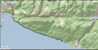
Taking advantage of a work trip to Victoria, BC, I met up with a fellow trekker, Jordan, to do an overnight hike on the Juan de Fuca trail on the last weekend in June. The challenges were a Saturday afternoon start for the drive out, only one car to manage a point-to-point hike and catching a red eye flight to Ottawa the next evening.

https://share.delorme.com/IngaPetri 
Success would require steady movement and a bit of luck: from dropping the car at our end point at Sombrio Beach and hitchhiking back to the trail head at China Beach, to making it to Bear Beach for our overnight, and an early start for the most challenging part of the hike. In total we would hike about 29 km with considerable cumulative elevation gain as the trail meanders along the coast from sea level up to 231 m and is hardly ever actually flat.

We managed it all with ease. The sweltering heat was kept at bay by the trail running through coastal forest and therefore endless shade. The timing issues with night fall and an early rise were handled deftly - such is the nature of necessity. We fueled well and made sure we stayed hydrated. We also got to take a look at our respective gear - from my inReach and ultra light 3 person tent, to Jordan's awesome cooking set up and creek crossing foot wear. Between the two of us, we seem to be in the right gear kind of shape for a long, unsupported remote traverse.

This trip was an exploratory excursion to see whether my new hiking pal and I would enjoy a 10-day remote back country trek in Northern BC this August. It appears we are the kind of compatible you'd want to be for an excursion like that. Now, there is just one final logistical item to iron out and we'll make a final decision about whether this trek is a go next month sometime next week.

Meanwhile where are a few impressions from Juan de Fuca. (Click on images to see them larger in slide show mode)
Morning fog from our camp side hideaway on Bear Beach.

Morning fog burns off.

Bear Beach views

For some a sign is reassurance. Then again, there is only one trail.

View from the trail.

Lots of creeks giving opportunity to experiment with camera settings.

Sombrio Beach was our end point this time. Heading up to the car
 and back to Victoria with enough time for a shower
before going to the airport ;)

Monday, August 27, 2012

Day 4 - riding out


Jan and horse on meadow.


The riding on day 4 was easy - the same way out, without any new blow down. The ride took only about 3 hours and was largely uneventful.

By now I was used to Jordi not liking bridges, so we simply found ways around them through the rivers and creeks.

Here are a few more impressions from horse camping in the Yoho back-country.
Afternoon sun and cloud spectacle.

Inga looking pretty comfortable in a saddle even on
 the fourth day. Jordi's a great trail horse.

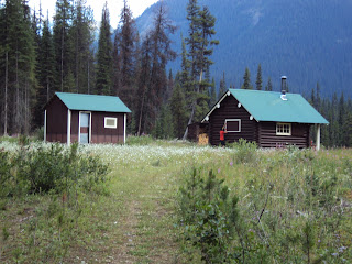
The warden's cabin on the small meadow.


The awesome river right below the cabin.
Goodsirs in background.


At the end of the trail, we find the trucks and horse trailers.
Here's Jan helping with the saddles and getting the horses
into the trailers for the ride home.


Sunday, August 26, 2012

Day 3 - Bushwhack!

After a couple of days of camping at Ottertail camp it was clear that there's not enough grazing for the horses for 3 days. It was also clear that the last 2 days of riding had been tiring and most of us were ready for an easier day.
Jan's happy taking care of the horses. She's also good at it.

Big Al and Dave in the kitchen.

Us at the edge of Ottertail Falls

Bushwhacking on horseback was a new kind of experience.
Wow!

So we rode up to Ottertail Falls and then attempted to access the river near camp via an old telephone route to the Cabin. The bushwhack was just that. Both horse and rider had to handle all manner of jumbled trees and the footing was progressively softer. In the end, we decided that this old route was not going to be feasible and turned around to head back to camp. It ended up being a shorter then hoped for riding day (just under 2 hours), but such is the nature of exploration.

You can lead a horse to water but ...
Jan and Al taking a couple of horses down to make sure they
are well hydrated.
Enjoying the afternoon at our private river hideaway!
Al and Dave brought the horses to a grazing spot across the river from the Warden's cabin so they'd be well fed and watered for our ride out the next day.

Saturday, August 25, 2012

Day 2 - Heading to Good Sir Pass

From our camp to Goodsir Pass, part of the famous Rockwall Trail, was just over 9 km one way. Today, would be a big day for us city gals.

Jan's happy and looking good on Bo.

Single track. Our guides were dealing with
trail clearing quite adaptly. Pays to have retired
Park Wardens as guides.
Leaving the fire road we were now riding on single track. It's obviously not a much travelled area, Al and Dave did lots of trail clearing of blow down. Some small and a quick axe job sufficed. Others sizable B.C. trees requiring knowledgeable saw work. Al and Dave handled all with aplomb.

We got to be tourists and wait from them on our horses. The horses, of course, took any opportunity to eat grass and some leaves during these frequent breaks. We reached the Pass after about 3.5 hours; after some steep climbing our horses had to do. We supported them as best we could, making our riding lessons count.

While there was plenty of grazing for the horses, there was no water for them. So we had a well earned rest, some lunch and got on our way back down.

Upon our return we got to a river we had crossed in the morning. Now, Al said, let your horses drink! And they did. We got back to camp after an awesome and exhausting riding day with about 6 hours logged!

Jan at our lunch spot with awesome mountain views.
While it's definitely easier to ride a horse up here than hike
with backcountry gear, it's still a great workout! 

Our horses get a break and graze to their heart's content.

Awesome views over the glaciated Goodsirs. They are
impressive at up to 3,500 m high.


Friday, August 24, 2012

Horses! Day 1

We'd already posted about heading to Bear Corner Breakfast and Bale. Now here are day-by-day posts on the 4 days riding in Yoho National Park. We quickly learned that this was an "exploratory trip." With the rain this spring and summer in B.C. Al's normal trail for a multi-day excursion was washed out; only the first 17 km are passable by car leaving us 33 km short of the trail head. Al needed another option for us.
Inga on ride in - took about 4 hours total due to all the
trail clearning required. I was on Jordi (Jordan), a great
horse for me.

Jan's riding in on Peach. The other days
she was on Bo. All fine horses with  varying
degrees of liking / dis-liking mad-made
structures like bridges.

Being a former warden, he made some calls and got a backcountry permit for our whole team, 4 people, 6 horses, including grazing permits in Yoho National Park. Having already hiked to Lake O'Hara in Yoho we were excited to experience some of the less trodden paths.
The horses were tied to trees for saddling/ un-saddling.
Other than that they had free reign in the meadow.

Our excursion was a little inauspicious as we drove in thunder and rain to our trailhead at Ottertail Trail,  located a few kilometres before Field, B.C., and the Lake O'Hara trailhead/road. By the time the 6 horses were saddled and packed and we got going, the rain had subsided and the weather began to clear.

At camp. Make-shift saddle storage.
We rode in 15 km. Al and Dave, our guides, smartly brougth both an axe and a Stihl saw. There was quite a bit of blow down to clear. This trail is an old fire road. We learned that the National Park Service was initially focussed on fire fighting and prevention, hence this infrastructure. Today they use helicopters to fight fires, making fire roads obsolete.

Even though the fire road is being reclaimed by nature, it still made for a relatively easy horse trail. This being the first day in the saddle and just getting to know the horses that was great.

Our team on the meadow. Al actually built the coral you
can see in the background back in his warden days.
To keep the horses close, all we needed
to do was to put 2 of them into the coral. The
others would stick close by. A rope across the path
did the rest.
We set up camp in the designated backcountry camping area near the Park Warden cabin. Around the cabin is a small meadow where the horses would graze and the camping and cooking/food storage areas were well divided for bear safety reasons.

We had a fine dinner, got the horses settled in and called it an early night.

Thursday, August 23, 2012

Rest Day!

Kicking Horse is a fun skier's resort mountain.
Riding the gondola in summer is way different than in winter
when we have all the gear and warm clothes.
Rest day means we took the gondola up Kicking Horse Mountain Resort :)
Here are a few more pics from that day, just to complete our earlier Blackberry post.

Also, while the food at the GMC was exceptional in any context, it was fun to have the full service experience at Eagle's Eye Restaurant at the top of the resort.

Our waitress was both funny and unobtrusive. And Jan made the gondola and lunch a present for having come to this fine country back on August 6, 1988.


Black diamond hiking trail from top of the gondola. Priceless.

At Eagle's Eye:
Green tomato gaspacho with scallop ceviche was awesome.

Scallops with bacon proved a worthy main. Thanks for the
24th anniversary in Canada celebration, Jan!

Wednesday, August 22, 2012

Lake O'Hara and Lake McArthur

Right after GMC we went to Lake O'Hara to spend that Sunday with friends from Toronto. The busses were full, so our only option was to hike in on the road. It's supposed to be 13.65 km or 11 km (we've been told both by authoritative sources - I'm going with 11km) and gain about 500m in elevation. Still, we managed it in two hours. The hike felt easy. We thought there were just a few steep sections.

Lake O'Hara. Jan's new Canon takes really nice pics.
Our friends had been told it would take us three hours so we had a bit of time to get a coffee and sit by Lake O'Hara awaiting their return from a short morning jaunt.

We decided to head up the short hike to Lake McArthur, which is really the postcard lake! It was a lovely hike up with plenty of catching up and storytelling along the way.

Lake McArthur. Even in the early afternoon it was calm,
allowing for those signature reflections of mountains.
Local wildlife boldly visited us at our rocky lunch spot.
We talked bears and mountain goats, mountains, lakes and icebergs.

We returned with a couple of hours to spare before the last bus at 6:30 pm would take us back to the road. We joined our friends for "happy hour" by the lake (so civilized) and then sadly had to get on our way.

Mountain goat. This was a mythical appearance on top
of the cliff near McArthur Valley.
When we boarded the bus, we were happy not to hike it out. Then a couple of kilometers into the ride, we suddenly looked at each other, realizing that the whole way so far had been downhill and quite steep.

We started laughing; amazed that we had interpreted the road as flat in the morning, when it so clearly isn't. I usually have great dislike for things like head winds and uphills (go figure!). This time, though, I think the training of a week at GMC set even me up to motor on this uphill like it's nothing!


Tuesday, August 21, 2012

GMC - Jan's Alpine Helicopter video

Flying by helicopter was a first for both of us. Jan got the front seat for the flight out to take this video. I've edited it for length and then created a lower resolution file out of this 1+gigabyte video. Check it out. (We have the full screen HD version; you can always come by our place for the full-on experience.)

GMC - Flying out August 4

Flight out and camp crew (Photo by Nataliya).
Chucky, Matt, Jen, Jeff (behind), Andrew, Ron and
 Julius (standing). Plus Jan and I at the helipad.
Packing up and flying out. That was sad.

The participants on this week worked very well together; lots of generosity and kindness, as well as skill, smarts and patience was on display all week.
Plants near the helipad.
Tea tent. Aptly named.

Where we did dishes. An ingenious set up.
We were on the second of nine flights, but still had plenty of opportunity to loiter about and take some extra pictures. (Just click on an image to see it large; then hit the back button in your browser.)

We came to the GMC to learn more skills and spend time with experienced mountaineers in this awesome landscape, as part of preparing ourselves for new objectives. We got that and more.

We are making plans now for our next big trip. I am sure they will be bold ones. Meanwhile, I am working on my mission (just like camp doc Ron's parting words implored) to get into great shape for these mountain pursuits.

It's time to apply the same vigour to the physical training as I have been applying to other aspects  such as learning Spanish (that's like a whole new language!) these past 2 years as part of trip prep.

Without doubt, details will be posted here as they unfold. I am quite certain that whatever the specifics, speaking Spanish will be a plus :)
Our last morning. Glorious weather greeted us along
with the moon over the Haworth glacier and Redan.